Throwback Thursday | Historic Bridge at Devil’s Gate

A little known Arroyo Seco bridge crossing led to the early development of Crescenta Valley

PHOTO: Pasadena Museum of History | SouthPasadenan.com News | Grand opening “first bridge” crossing of the Arroyo Seco at Devil’s Gate (1893)

The narrow passage in the upper Arroyo Seco was referred to as Devil’s Gate by early Pasadena residents because the profile of a devil’s face appears on the cliff at the right.

PHOTO: Pasadena Museum of History | SouthPasadenan.com News | Local area residents pose for a picture at Devil’s Gate (1888)

In the photograph above, a man sits on top of the devil’s horn. The granite outcropping was a favorite community gathering spot. Local area residents would pack lunches for their family picnics at Devil’s Gate.

PHOTO: Pasadena Museum of History | SouthPasadenan.com News | Grand opening “first bridge” crossing the Arroyo Seco upstream from Devil’s Gate (1893)
4: PHOTO: Pasadena Museum of History | SouthPasadenan.com News | Community picnic under the historic “first bridge” near Devil’s Gate (1893)

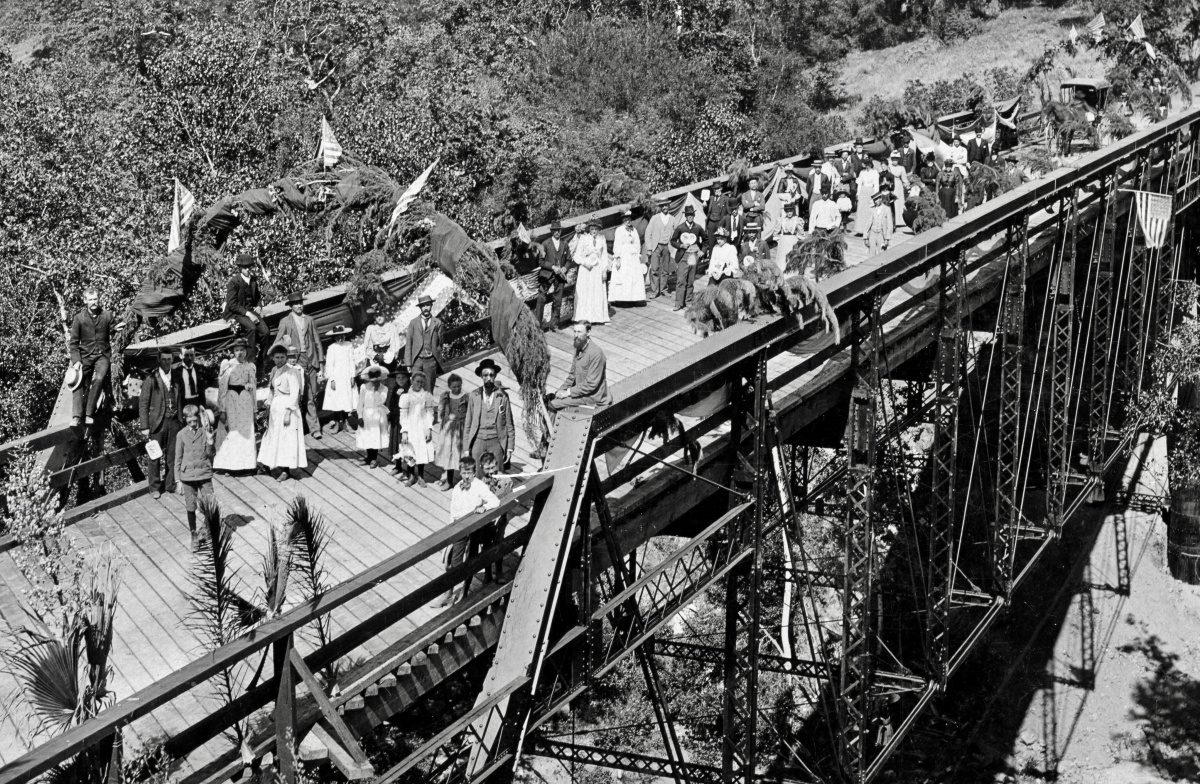
In 1893, Crescenta Valley and Pasadena residents gathered to celebrate the grand opening of the first bridge to cross the Arroyo Seco at Devil’s Gate. The bridge became a vital link between Crescenta Valley and the City of Pasadena and San Gabriel Valley.

- Advertisement -

Community picnic (photo above): Ms. Ameretta Lanterman (first to the left of the keg) is the grandmother of community leader and California Assemblyman, Frank Lanterman.

PHOTO: Pasadena Museum of History | SouthPasadenan.com News | View of bridge from the riverbed of the Arroyo Seco (1893)
PHOTO: Pasadena Museum of History | SouthPasadenan.com News | View of the bridge and Arroyo Seco riverbed (1899)
PHOTO: Pasadena Museum of History | SouthPasadenan.com News | Long view of the bridge and future site of the Devil’s Gate Dam (1899)

In 1920, flood engineers built a dam at Devil’s Gate. With a height of 103 feet and a length of 252 feet, the concrete dam replaced the wood-planked bridge as the primary bridge crossing between Pasadena and the Crescenta Valley.

PHOTO: Pasadena Museum of History | SouthPasadenan.com News | The Devil’s Gate Dam during construction with the historic “first bridge” visible behind it (1920)
PHOTO: Pasadena Museum of History | SouthPasadenan.com News | The bridge is still standing after the construction of the Devil’s Gate Dam (1921)
PHOTO: Pasadena Museum of History | SouthPasadenan.com News | A massive lake forms behind the Devil’s Gate Dam (1938)

In 1938, historic high-level of storm water runoff collects behind Devil’s Gate Dam covering everything except for the two telephone poles.

Today, Devil’s Gate has become a major transportation corridor: 210 freeway, Devil’s Gate Dam (closed to automobile traffic but still accessible to equestrians, bicyclists, and hikers), and a third bridge directly in front of the dam.

Note: The historic “first bridge” was demolished during the 1920s. However, its original concrete footings have survived and are easily accessible today behind Devil’s Gate Dam.

Throwback Thursday is written and produced by Rick Thomas


Rick Thomas
Author Rick Thomas is the former museum curator and vice-chair of education for the South Pasadena Preservation Foundation. He served on the South Pasadena Natural Resources Commission, helping to maintain a strict policy protecting the city’s great old-growth trees. Using touchstone photographs from his own collection—one of the San Gabriel Valley’s largest accumulations of historical images and artifacts—as well as national, state, and local historical archives, Thomas provides a window to his city’s past and an understanding of why its preservation is so important.