


California fire officials have released new Fire Hazard Severity Zone (FHSZ) maps for local areas – the first update in over a decade. These maps classify fire risk in communities like South Pasadena as Moderate, High, or Very High hazard based on science-driven models of wildfire potential.
Los Angeles County is now required to adopt the updated maps by ordinance within 120 days of March 24, 2025, and public hearings will invite community input before the maps become official. Here’s what South Pasadena residents should know about the new FHSZ maps, why they matter, and how they may affect local homeowners.

What Are Fire Hazard Severity Zone Maps?
FHSZ maps are state-developed wildfire hazard maps that show which areas face the greatest likelihood of wildfires. Cal Fire (the state fire agency) creates these maps using a science-based and field-tested model. Many factors are considered, including a location’s wildfire history, vegetation (fuel), terrain steepness, typical hot/dry winds, and even how far embers might travel. Based on these factors, each area is rated Moderate, High, or Very High fire hazard.
Importantly, these particular 2025 maps cover Local Responsibility Areas (LRA) – cities and towns where local fire departments handle wildfires (such as South Pasadena). This is separate from the maps for State Responsibility Areas (SRA), which cover wildland areas where Cal Fire is the primary responder. (Federal lands aren’t included in these state maps.) The last update to LRA fire hazard maps was in 2011, so this 2025 update reflects over a decade of changes in climate and wildfire patterns.
Why was this update done now? After a series of destructive fires in early 2025, Governor Newsom ordered agencies to accelerate wildfire safety efforts. Updating the hazard maps helps identify the neighborhoods most at risk and guides where to focus mitigation work. Cal Fire officials say the new maps “reflect the realities firefighters already know” – that climate change is worsening fire hazards across California. They hope the maps will be a call to action for residents to prepare for wildfires.
Why the New Maps Matter
These hazard designations are far more than just labels on a map – they carry real-world implications for building codes, landscape maintenance, insurance, and community safety planning. State law ties many requirements to whether a property is in a “High” or “Very High” fire hazard zone:
-
Fire-resistant Building Standards: New construction (and many major remodels) in High or Very High zones must follow strict wildfire-resistant building codes. This is outlined in Chapter 7A of the California Building Code, which requires features like fire-rated roofs, multi-pane tempered glass windows, and screened attic vents to resist embers and heat. These home hardening measures greatly improve a house’s chance of surviving a wildfire. Even if your South Pasadena home was built before these rules, any new additions may need to comply with them. Over 90% of existing homes in fire-prone areas were developed before today’s standards, so officials are educating homeowners on how to voluntarily harden older homes as well.
-
Defensible Space & Vegetation Management: If your property is in a Very High FHSZ, you are legally required to maintain defensible space – that means clearing flammable brush and keeping vegetation thinned within 100 feet of your home (or to your property line). This reduces fire intensity and gives firefighters a chance to protect your house. South Pasadena residents in hillside areas may already be familiar with annual brush clearance notices – those practices will continue and become even more crucial under the new maps. Even in “High” hazard areas, regular yard maintenance and removing dry vegetation is strongly encouraged (and may be enforced by local fire code rules) to slow the spread of fires.
-
Real Estate Disclosures: Sellers of property in a Very High fire hazard zone must disclose that fact to buyers under California law. This ensures that new homeowners are aware of the wildfire risk and the associated responsibilities. While disclosure isn’t mandated for “High” or “Moderate” zones, knowing your home’s designation is still important for making informed decisions about insurance and upgrades.
-
Community Planning and Infrastructure: Local governments also use these maps in planning decisions. For example, city and county agencies must consider evacuation routes, water supply, and the placement of critical facilities in relation to fire hazard zones. In practice, that means identifying safe evacuation roads for high-risk neighborhoods and, when feasible, avoiding building new hospitals, schools, or emergency centers in the highest hazard areas. These steps help improve overall wildfire resilience for the community.
-
Insurance Considerations: Many residents worry how a “High” or “Very High” label will affect their home insurance. The good news is that insurance companies already use their own sophisticated fire risk models – they don’t rely solely on state FHSZ maps when setting rates or deciding coverage. In fact, California’s Insurance Commissioner emphasizes that a change in your home’s zone (for example, from High to Very High) is unlikely to affect your insurance by itself. However, the reality is that wildfire-prone areas in general have seen rising premiums and some insurers pulling back. The updated maps underscore the importance of mitigation: under new regulations, insurers must offer discounts to homeowners who harden their homes and create defensible space, actions which these maps encourage. In short, a safer home is not only better protected from fire – it may also be easier to insure. Local insurance experts note that companies increasingly want proof of risk reduction (like cleared brush and fire-resistant construction) before renewing or issuing policies.
By clearly identifying the highest hazard zones, the new maps aim to boost wildfire preparedness. Reducing wildfire risks throughout the state is the primary way we can make insurance more available and affordable. In the end, the designations matter because they drive investments in stronger homes, safer landscaping, and smarter community planning – all of which can save lives and property when wildfire strikes.
How South Pasadena and L.A. County Are Affected
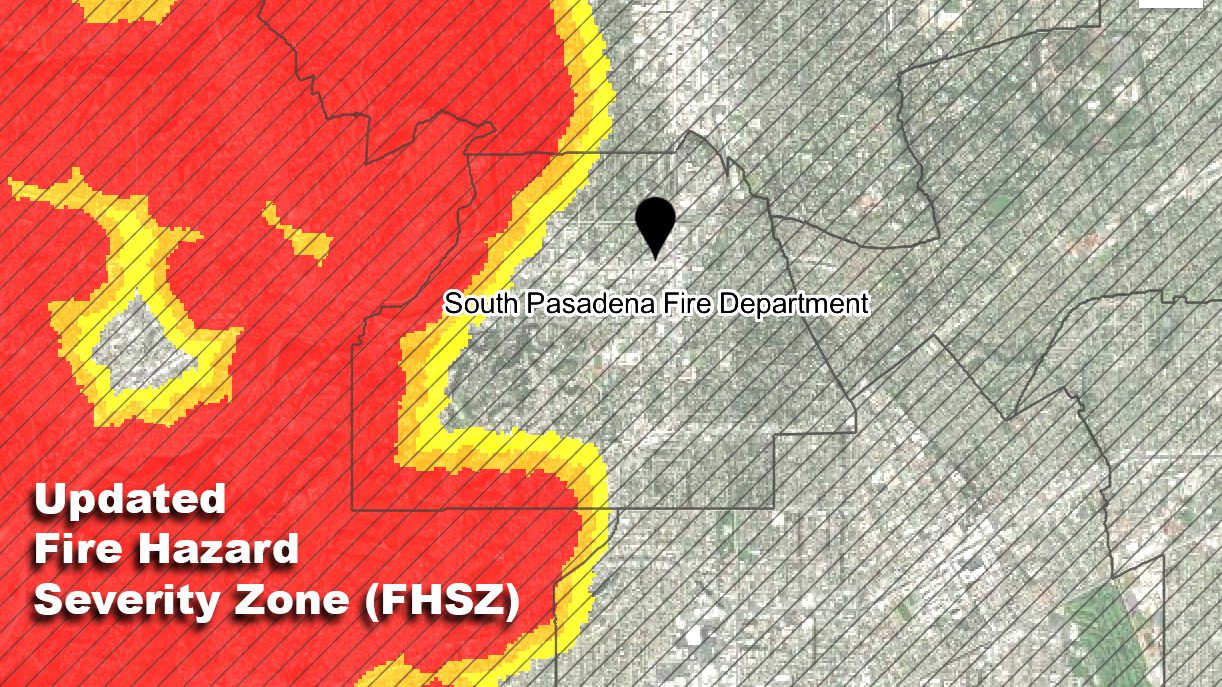
 Los Angeles County officials report that the number of local parcels falling within designated hazard areas is likely to increase under the new maps. In Greater L.A., roughly 900,000 acres are now classified as “Very High” fire hazard – about a 29% increase from the old 2011 maps. Many of the additions are in foothill communities and wildland-adjacent areas. For instance, in Altadena (just north of Pasadena), the Very High zone has crept further into neighborhoods, and the hazard zones now reach the area near the Rose Bowl and even toward the SR-710 freeway in Pasadena, close to South Pasadena’s northern edge. This means parts of our local area that previously were not considered at extreme risk might now be included as “High” or “Very High” hazard on the state map.
What about South Pasadena specifically? Our city is relatively small and urbanized, but we border natural open spaces (like the Arroyo Seco and hillside areas) that can carry wildfire risk. In past maps, South Pasadena had only small sections, if any, marked as Very High fire hazard. With the 2025 update, it’s possible that some peripheral areas (for example, near Monterey Hills or the city’s wooded parklands) may be newly classified as High hazard zones, reflecting the potential for wildfire to encroach. Residents are encouraged to check the new map to see if their property’s status has changed. Even if your property remains outside the highest zones, the expanded designations around us serve as a reminder that wildfire risk is a regional concern, and mitigation efforts are important for everyone in the community.

Los Angeles County fire officials have made it clear that they are not proposing any additional hazard areas beyond what the state has identified. In other words, the County will adopt Cal Fire’s recommendations as-is, without expanding zones further into areas not already flagged by state experts. By law, local jurisdictions may choose to add or elevate hazard zones in the adoption process, but they cannot remove or downgrade any zones that the state has designated.
Because the science behind wildfire modeling has improved, some neighborhoods that were not previously labeled high-risk are now shown to have a significant hazard level. More area in our region is colored in bright orange (High) or red (Very High) on the new maps than before. County leaders urge residents not to be alarmed, but to be informed. These changes don’t mean an immediate danger is looming – rather, they indicate where we should focus on prevention and preparedness. South Pasadena homeowners should take this opportunity to understand their wildfire risk and what steps might be required or recommended for their property.
Implications for Homeowners: Building Codes and Safety Rules
For South Pasadena residents, a key question is: If my property is now in a High or Very High fire hazard zone, what does it mean for me? Here are the practical impacts and responsibilities that come with these designations:
-
If your property is in a Very High Fire Hazard Severity Zone: You will be required to maintain 100 feet of defensible space around your home (clearing dry brush, pruning trees, and removing other fire fuels) on an ongoing basis. South Pasadena’s fire authorities (in coordination with L.A. County Fire) typically conduct annual inspections in high-risk areas to ensure compliance. You’ll also need to follow Wildland-Urban Interface building standards (California Building Code Chapter 7A) for any new construction or major remodels. Additionally, if you decide to sell your home, you must disclose in the real estate paperwork that the property lies in a Very High fire hazard zone.
-
If your property is in a High Fire Hazard Severity Zone: While the defensible space law (100-foot clearance) technically applies to Very High zones, it’s highly recommended that High zone properties also maintain similar brush clearance for safety. New homes or additions on your property will need to meet the same wildfire-resistant building codes as mentioned above. Even if you’re not building anything new, consider retrofitting key parts of your home (like installing fire-safe vents or clearing rain gutters regularly). These proactive steps can protect your house and may even earn insurance discounts. While sellers don’t have a state-required disclosure for High zones, being forthcoming about wildfire risk and mitigation measures is wise.
-
If your property is in a Moderate Fire Hazard Zone (or not in any mapped zone): No special state mandates apply to these lower-risk areas beyond normal fire safety ordinances. However, South Pasadena’s fire officials urge all residents to stay vigilant. Simple measures like keeping yards free of excess dry brush, using fire-safe landscaping, and having an emergency evacuation plan are recommended for everyone – not just those in the designated zones.
It’s Now Your Turn To Speak Up: Map Adoption and Public Input
Los Angeles County now has until late July 2025 to formally adopt the new FHSZ maps by ordinance. The L.A. County Board of Supervisors is expected to schedule public hearings in the coming weeks so that residents, cities, and other stakeholders can weigh in on the proposed map adoption. Public participation is welcome and encouraged during this process.
-
View the Updated Map: South Pasadena residents can check their property’s fire zone on the new map by using Cal Fire’s online viewer. Visit the Office of the State Fire Marshal’s FHSZ Viewer and enter your address to see if your home falls in a Moderate, High, or Very High zone. (Every property lot in South Pasadena is in the map)
-
Attend Public Hearings or Comment Online: Once hearing dates are announced, locals can provide input in person at the County Board of Supervisors meetings or through written comments. You can submit e-comments on the agenda item or send letters for the record. L.A. County Fire Department has indicated it will collect community feedback during the adoption process.
-
Sign Up for Updates: To stay informed, residents can subscribe to notifications about fire safety and public meetings. Following the South Pasadena Fire Department and L.A. County Fire Department on social media is another good way to get announcements. The South Pasadenan will also continue to report on key developments, including when public hearing dates are set.
Considerations for a Fire-Resilient South Pasadena
By identifying high-risk areas, resources can be directed where they’re needed most – whether that’s clearing overgrown brush in the hills, upgrading an older home’s roof and windows, or improving emergency response plans. South Pasadena may not have large wildlands within city limits, but we are part of the greater ecosystem of the San Gabriel Valley and Los Angeles County, where wildfire is a natural threat. The Arroyo is included and various volunteer groups work with city officials to help maintain the area.
The new designations serve as a reminder of our shared responsibility in wildfire preparedness. Homeowners can take practical steps like those mentioned, and neighbors can work together on creating Firewise USA communities or other cooperative mitigation projects. While seeing your property included in a Very High Fire Hazard Zone can be concerning, remember that this does not mean wildfire is imminent or guaranteed. It means that if a wildfire were to occur in our area, the conditions at your location could allow fire to spread rapidly.
South Pasadenans Engagement is Crucial: With this information, you can better protect your home and family. Wildfire resilience is achieved through awareness and action.
South Pasadena residents along with our close neighbors in Altadena and Pasadena have realized the catastrophic reality of wildfire outcomes – through safer building practices, diligent yard maintenance, and community emergency planning – South Pasadena must be better prepared for whatever fire season brings.
For more information, visit the Cal Fire Fire Hazard Severity Zones webpage or the L.A. County Fire Department website. The interactive map and FAQs can be found at osfm.fire.ca.gov. South Pasadena City Hall and the South Pasadena Fire Department are also available to answer local questions.


