














The 80-degree November is over
A very active North Pacific has finally broken down the warm offshore pattern that cooked Southern California most of this week, and the National Weather Service office in Oxnard is calling what comes next a “storm train.”
The first weather arrives Thursday overnight into Friday. Rain is expected to spread into Los Angeles County after midnight tonight. A cold front follows late Friday with a second, wetter round lasting into early Saturday. After a dry Sunday, two more systems are lined up for next week.
None of this is a blockbuster for Pasadena and South Pasadena. Expect a soaking measured in fractions of an inch, slick roads for two commutes, a sharp drop in temperatures and rough surf at the beaches.
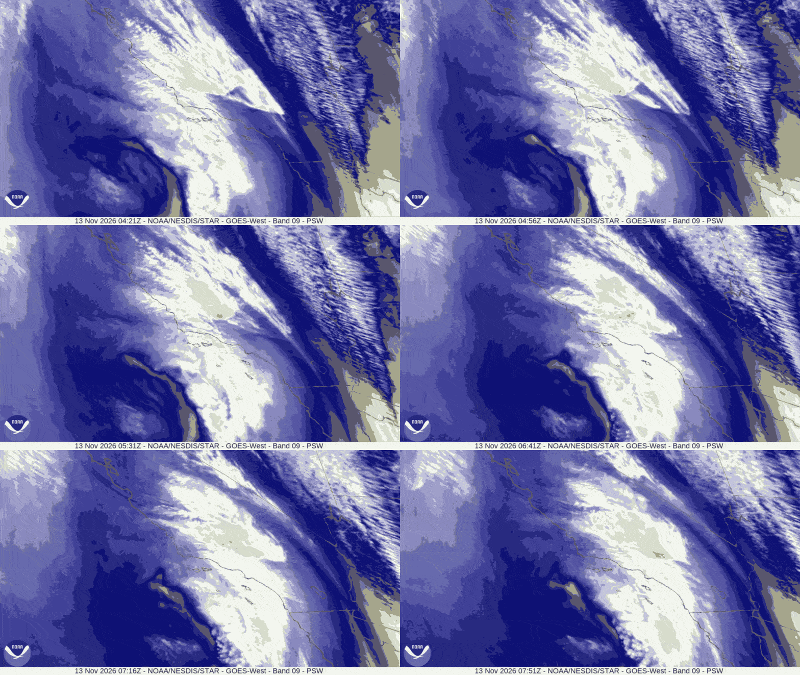
What The Satellite Shows
Two separate weather patterns are at work.
First, an upper-level low west of the area is sliding south and east into northern Baja tonight. Its best showers stay south and east of Los Angeles County, so Round One is light for most of us. It carries enough unstable air to produce pop-up downpours and a few thunderstorms, mainly south of Point Conception along the coast and coastal plain.
Second, a cold front sweeps across Southern California Friday afternoon and Friday night. That is the more organized, more widespread rain.
Behind both, a strong low-pressure system in the far North Pacific near the Aleutian Islands is sending enormous swells toward the coast. That is the storm’s biggest local footprint this weekend.
The Timeline for Pasadena and South Pasadena
Tonight (Thursday Night): Clouds thicken. Showers become likely after about 4 a.m., with less than a tenth of an inch expected. Low around 56.
Friday Morning: Showers likely, mainly before 10 a.m. The morning commute is the wet one in Round One. Because tonight’s showers come from unstable air, some neighborhoods may get a quick downpour while others a mile away stay nearly dry.
Friday Afternoon: A lull for most of the day, then rain chances return after about 4 p.m. as the cold front approaches. High near 73, the last warm day in the forecast.
Friday Night: This is the main event locally. Rain is most likely between about 10 p.m. and 4 a.m., with a tenth to a quarter inch expected and locally more. Gusty southwest to northwest winds accompany the front. Low around 53.
Saturday: A chance of lingering rain before about 10 a.m., then clearing to mostly sunny. High near 69. Saturday night is partly cloudy and noticeably cooler, with lows around 52.
Sunday: Dry, with highs in the upper 60s. This is the break between storms.
How Much Rain?
Round One, tonight into Friday afternoon: a quarter inch or less for most areas, with locally higher amounts under any thunderstorm or heavy shower.
Round Two, late Friday into Saturday morning: a quarter inch to three-quarters of an inch, with more on favored mountain slopes.
Storm total through Saturday morning: a quarter inch to one inch for most areas.
Rain rates should mostly stay under a quarter inch per hour. Forecasters give a 20 to 30 percent chance that some spots briefly see rates near half an inch per hour.
Commuter Report: Downtown LA, the 110, the 210 and the San Gabriel Valley
Friday Morning Commute: Plan for wet roads. This is the first real rain after a long, warm, dry stretch, so oil and dust on the pavement will make freeways slicker than the rainfall totals suggest. The Arroyo Seco Parkway (the 110 between Pasadena and downtown) is the one to respect – slow down.
Friday Evening Commute: Rain chances return after about 4 p.m., and sunset is around 4:50 p.m. That means many drivers will head home in the dark with the front’s leading edge arriving. The heaviest rain is expected later, after 10 p.m., so an earlier departure is the better bet.

Saturday Morning: Wet roads early, improving by mid-morning.
Monday Morning Commute: The next system is due Sunday night into Tuesday. Monday’s drive is likely to be wet again.
Expected Weather Around the Region
Downtown Los Angeles and the LA Basin: Similar timing to Pasadena. Round One is light and spotty overnight, with the front bringing steadier rain Friday night. The best chance for any thunderstorm is from the basin south toward Orange County late tonight and Friday.
San Gabriel Valley (Alhambra, San Gabriel, Arcadia, El Monte, Pomona): Same two-round pattern. The foothill communities along the 210 will run at the wetter end of the range.
Glendale, Burbank and the San Fernando Valley: Light showers overnight, steadier rain with the front Friday night. Highs drop into the 60s by the weekend.
Foothills and San Gabriel Mountains: Favored slopes will see the highest totals. Gusty winds are expected Friday and Friday night, with a chance of low-end advisory-level gusts in interior areas. Next week turns genuinely cold up high, with mountain highs in the 40s and 50s and overnight lows possibly dipping into the mid-20s.
Beaches: See below. This is where the real hazard is.
Foothill and Burn Area Note
As of the latest forecast discussion available Thursday, the weather service had not issued a flood watch for Los Angeles County. Expected rain rates are modest. The higher-end scenario, brief rates near half an inch per hour, is the one residents near the Eaton Fire burn area in Altadena and Sierra Madre should keep in mind. Keep phone emergency alerts on overnight Friday.
Beaches: Big Surf All Weekend
A series of very large, long-period west-northwest swells will pound the coast through at least Tuesday.
A High Surf Advisory is in effect for Los Angeles County beaches from 2 p.m. Friday to 3 p.m. Tuesday. Ventura County beaches are already under a High Surf Advisory through 3 p.m. Tuesday.
Breaking waves of 4 to 7 feet are expected Friday, building to 7 to 12 feet Saturday, then easing to 6 to 9 feet Sunday through Tuesday. Surf peaks Saturday.
Expect beach erosion and shallow seawater flooding of low-lying beach walkways, parking lots and roads, especially near the morning high tides. Dangerous rip currents, sneaker waves and heavy shore break are likely. West-facing beaches take the worst of it. South-facing beaches see less.
There is a low chance of warning-level surf on Ventura County beaches Saturday. The Central Coast is under a High Surf Warning and a Coastal Flood Warning for Saturday, with breakers of 18 to 25 feet possible on northwest-facing shores.
If you’re heading to the beach this weekend, watch from a safe distance. Stay off rock jetties and out of the water unless you’re near an occupied lifeguard tower.
Next Week: Two More Storms
Sunday Night Through Tuesday: The next system is expected to bring a tenth to half an inch. Monday looks like the wettest day of this round.
Wednesday and Wednesday Night: A stronger system could bring a quarter inch to one inch.
Forecasters give a 10 to 20 percent chance that totals come in higher than the current numbers. Highs stay mostly in the 60s all week, with partly to mostly cloudy skies.
Remember to turn off the sprinklers.